 We met at 7:30am and began our hike. The Pine Creek trail is a simple dirt path for the first 1-1.5 miles, beginning at about 4000 feet above sea level. At Mescalito, the trail forks. Our path was the right fork into Fern Canyon.
Starting out on the dirt path, approaching Mescalito in the middle:
 Fern Canyon was beautiful. Water flowed in a creek and it was surrounded by thick vegetation. Because of all of the trees, it was much cooler in here.
 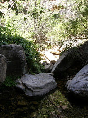 Eventually, the canyon became drier with fewer trees and plants, and the class 3 scrambling began. See how happy we are to come to boulders:
 Here I am climbing up some boulders:
 At first, the boulders were pretty simple to get over, but eventually we came to a steep wall. Rick and Parnell decided to scale the wall, but Mike and I found a path up some boulders to the right of the wall. Here I am at the top of the wall:
 At the top, the view overlooking Pine Creek Canyon was beautiful.
  At this point, there was no longer a clear trail. The wash continued, but we decided to start up the canyon wall. There were cairns every so often to let us know that we were heading in the correct direction. Here is the view as we looked ahead. We were trying to get to the top of the ridge directly ahead so that we could begin the trek over to Bridge Mountain.
  We were pretty high up at this point on slick tilted rock. Going up seems so easy, but it's intimidating as soon as you look down to see where you came from. Eventually, we stopped seeing the cairns and no longer knew which way to go. Parnell tried one direction, but it was a nearly vertical wall that made even him nervous. Mike tried another direction, but the footholds ran out and he had to come back. Here is Mike, the dot in the center of the picture, trying to find a route for us.
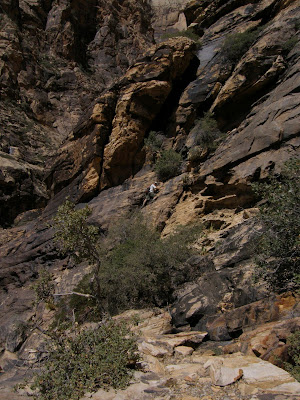 Alas, we had been hiking for four hours and decided to give up. We figured that this route was just too difficult to do without equipment. We had an awesome time bouldering, but the summit was not meant to be for this day. We made it back to the car six hours after we started, and we went out for a much-needed lunch.
When I got home, I looked at the website of the couple who had taken Pine Creek to get to Bridge Mountain. It turns out that if we had stayed in the wash, we would have found an easier route up to the summit. Looking at their topo map and GPS route, we had made it about 2.5 miles in, and we only had about 1.5 miles to go. We had ascended about 1500 feet of the 3000 feet to the summit. There's no telling how long it would have taken to finish that last mile and 1500 feet elevation gain because the route was just going to get scarier, but it's disappointing that we were so close to our goal. Next time the temperature cools down, we will try this peak again, perhaps with a different starting point.
Click here for more pictures from our hike


1 comment:
The "finding a route" part was fun; that whole exploratory feeling we had trying to find the way! =)
Post a Comment